UNIT 4
LANDFORMS OF SPAIN

THE MESETA:
Meseta is an extensive flat terrain located more than five hundred meters over sea level.
The Meseta is the plateau at the centre of the Peninsula. It is the most extensive and highest in Europe.

In the Meseta´s interior are the Central System and the Toledo Mountains.

In the Meseta´s borders are the Mountains of León, the Cantabrian Range, the Iberian System and Sierra Morena.
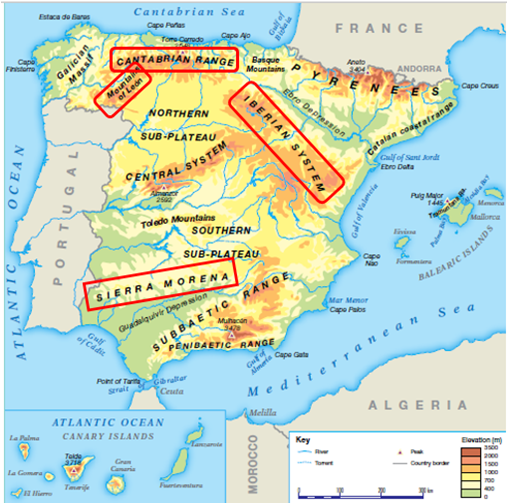
Outside the meseta: There are four mountain ranges in the north of Spain: The Galician Massif, the Basque Mountains, the Pyrenees and the Catalan Coastal Range; and two are in the south: the Penibaetic Range and the Subbaetic Range.

The Mulhacén is the highest peak on the Peninsula and is in the Sierra Nevada (the Penibaetic Range).

There are two large depressions: the Ebro Depression and the Guadalquivir Depression.

The Spanish coastline can be divided into: the Atlantic coast of Cantabria, the Atlantic coast of Galicia, the Atlantic coast of Andalucía, the Mediterranean coast of Andalucía and the Eastern Mediterranean coast.
Ceuta and Melilla are autonomous cities found south of the Mediterranean Sea.
The Spain´s archipelagos are the Balearic Islands and the Canary Islands.
The Balearic Islands are an extension of the Subbaetic Range and the highest altitude is the peak of Puig Major.
The Canary Islands are mountainous and volcanic in origin and the highest altitude is the Teide.

The Teide is the highest altitude in Spain and is in the Canary Islands.
ACTIVITIES
1. Dividimos el folio en 4 partes iguales y apuntamos las formas del relieve que encontramos en el interior, en los bordes, fuera de la meseta y el relieve costero.
2. Pasar a nuestro mapa físico mudo las formas del relieve que hemos estudiado atendiendo a distintos colores para diferenciarlas entre ellas.
3. https://mapasinteractivos.didactalia.net/comunidad/mapasflashinteractivos/recurso/relieve-de-espaa/b08c36e5-ed54-46e1-995f-354b59d8dd08


Comentarios
Publicar un comentario